Tampilkan postingan dengan label Ross Barney Architects. Tampilkan semua postingan

Selasa, 14 Oktober 2014

Passengers as Butterflies: Ross Barney spins Clear Cocoon on Cermak


click images for larger view
According to the history on the indispensable Chicago-L.org website, there was a station at Cermak for more than three-quarters of a century.  It was one of ten stations along 1892's South Side Rapid Transit, Chicago's first �L� line.  Cermak was never much more than a utilitarian design.  It reached its peak carrying passengers to the Century of Progress Worlds Fair in 1933 and 1934.  As the neighborhood declines in the 1960's, so did boardings at Cermak.  In 1976, hours of operation were curtailed to, ultimately, being open for little more than rush hours.  In 1977, the station closed for good, and was demolished the following year.
Right now on the Green Line, there's a massive three-mile "no-man's land" gap between the Roosevelt stop, and the next one at 35th.  But things change.  Shortly after the turn-of-the century, Bertrand Goldberg's iconic Hilliard Homes underwent a major rehab.  The former gauntlet of auto parts stores constricted.  For the moment, Blue Star Auto endures as a memorial.  New housing and schools became to pop up, with the coffee shops, hair salons and other signs of gentrification close behind.
As early as 2002, the CTA began planning to resurrect a station at Cermak.  In 2011, incoming Mayor Rahm Emanuel announced plans for a new Cermak-McCormick Place Green Line Station station to serve both a reviving community and two of the sugar plums he has dancing in his head: a Motor Row entertainment district, and the new DePaul basketball arena.
rendering: Ross Barney architects
At a estimated cost of $50 million, which the usual TIF slush fund picking up the tab, the station is   designed by Ross Barney Architects, whose new Green Line station at Morgan Street, became at once a perfectly timed amenity and the visual marker for the booming Fulton Market District. Now, Ross Barney stands to be making the same kind of landmark on Cermak.
Koolhaas tube, IIT
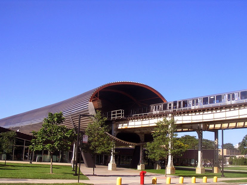
The immediate precedent to the Cermak station is Rem Koolhaas's steel tube, created to isolate train noise from his new IIT McCormick Tribune Campus  Center, but there the station is south of the tube.  At Cermak, the station is the tube.
rendering: Ross Barney architects
 According to Ross Barney architects . . .
rendering: Ross Barney Architects
The station is to be built quickly, with a modest budget, without suspension of service, and of durable, low-maintenance materials. This portion of the Green Line runs within city blocks on a narrow right-of-way. Tracks could also not be moved and, as a result, narrow platforms would have to serve trains in an area with an anticipated growth in population and transit use. In addition, the client, the City of Chicago Department of Transportation, wanted a �gateway� treatment for this station that is anticipated to serve a high number of first-time visitors to Chicago.
rendering: Ross Barney Architects
A resolution of the tension in the demands of the project -- Low-cost, speedy construction, no track relocation, narrow right-of-way, and a memorable gateway � was the development of a tube over Cermak Road. Cermak Road is where the right-of-way is widest and also the spot that is most visible to the public. Locating the primary berthing for trains over Cermak Road allows for views to Chinatown, McCormick Place, and Chicago�s Loop. The perforated stainless steel and polycarbonate tube performs multiple duties: Wind and rain protection and their supports are kept off of the platform, creating more comfortably usable space for customers; materials are moved out of easy reach of vandals; and the station is easy to identify from a distance.

Glass, polycarbonate, and perforated stainless steel are used to maximize visibility, views, and natural light in the station houses and on the platform. Where used alone, the percentage �open area�, the amount of material that has been removed, in the stainless steel panels is never more than 23%. With this amount of open area, stainless steel can both provide views to and from the platform and reduce the discomfort of usual winter winds.
Ground was broken in August of 2013 for what will the 146th CTA station,  will entrances both on either side of Cermak, and at 23rd street. 
By June of this year, construction was moving along nicely . . .
  . . . with a whole lot of concrete being poured.
 Last weekend, things were coming clearly into shape.  This is what the main station house looked on Saturday . .  .
. . . and here's how it looks, completed, in this Magritte inspired rendering in which the entrance leads nowhere - no platforms, stairs or escalators are included in the depiction.  
Rest assured they'll be in the finished product, and the elevator tower is now clearly in evidence.
  The beauty of the structure is already emerging, both in its light and elegant structure . . .
. . . and the way the sunlight glistens through the translucent glass sheathing . . .
 Construction has required ten hour suspensions of Green Line service on a succession of weekends, with the last slated for 1:40 to 11:40 a.m. on both Saturday October 25th and Sunday the 26th.
It must be quite a show to see those great arched steel sections being lifted into place.
The stated completion time for the project is the end of the year.
rendering: Ross Barney Architects
Read More:

Instant Landmark: TranSystems and Ross Barney's Morgan Street Station

Kamis, 08 Agustus 2013

Sour Disposition Friday: Vue53 and The 606

OK, I apologize in advance, but I just have to get it out of my system . . .

Valerio Dewalt Train does good work.  I've recently posted on their Earl Shapiro Hall, at the U of C Lab Schools, and I'm quite fond of EnV, across Wells from the Merchandise Mart.
click images for larger view
However, with apologies to the Infinite Monkey Theorem, I'm thinking that if you combined a roomful of architects with a roomful of community activists and let them loose on 3D rendering software for an infinite amount of time, the result would look something like this . . .
rendering:  Valerio Dewalt Train
This is Vue53, the end product of a lot of iterations and consultations with the Hyde Park community.  It replaces a Mobil gas station and car wash at 53rd, between Kenwood and Kimbark.  As you can see in this presentation, Vue53 meets all kinds of desirable metrics on affordable housing, minority participation, transit-oriented development and the avoidance of TIF funding.  Everyone appears to agree it's a wonderful thing.

Am I the only who finds this design, especially compared to the new construction in and around Harper Court, numbingly banal?  It looks like the alley end of a big-box store, spit up into the sky. 
rendering: Valerio Dewalt Train
My bet is this is the kind of building that, only a few decades from now, will keep a new generation of community activists very busy trying to figure out a way to get it torn down.

*********************************************************

Meanwhile, on the near northwest side, another hardy group of community activists is about to see their decade-long dream realized.  Work has begun on The Bloomingdale Trail, the conversion of an abandoned 2.7 stretch of rail line into a raised public park modeled after the wildly successful High Line that's revitalized New York City's meatpacking district.  A design team led by ARUP and including Ross Barney Architects, ARUP and Michael Van Valkenburgh Associates, has created a striking vision . . .
It will be a great thing.  Even the name - roll it around on your tongue: Bloooooooomingdale.  Just that long vowel sound carries the promise of something wonderful.  The very word - Blooming - evokes images of all the wonderful landscaping, �Dale� the way it flows through the neighborhoods like a valley on a viaduct, and �Trail� the spirit of adventure that invites you to explore it.
Well, we can't have that, can we?

Members of the project's advisory board emitted the bureaucrat's native cry, �Bring on the consultants!� and a consultant appeared, charged with creating a new name for the project,  encompassing both the reconstructed viaduct and the five parks to be aligned with it.

And what was the  product of all their labors?  (Wait for it):
No, I'm not making this up.  It was unveiled this past June, and far more interesting than the name itself is the enterprise with which various participants began spinning, spinning, spinning the Emperor's New Clothes to convince themselves this wasn't a nakedly bone-headed idea.

�When it was first presented, we all sort of went, �huh?� one participant told The Huffington Post. �And then when it�s explained to you, it makes an enormous amount of sense.� New Rule: If you need a personal briefing to even begin to figure out what a name means, it's probably not a good name.

The consultants said people didn't understand what the Bloomingdale Trail referred to.  And when we say �people�, we mean out-of-town donors.  Apparently it was felt it will be easier to raise money for �The 606�.  (Which, in case you haven't guessed, refers to the three-digit prefix of the zip codes used, not just in the vicinity of the Bloomingdale Trail, but across every last one of Chicago's 234 square miles.)

The new name is the work of the usually highly capable Branding Agency Landor Associates, which somehow didn't seem to notice the tenuous relationship between �The 606� and the firm's own Eight Principles of Naming.

1.  Make it memorable.
�The 606� is about as memorable as the serial number on the ticket you get from the dispenser at the deli counter.
2.  Fill it with meaning.  
�The 606� - Is it a highway designation? An area code?  A sign of demonic possession that lost its nerve?
3.  Say it out loud.
Watch people stare and wait for the men with the big nets to take you away.
4.  Don't wait to fall in love.
Fast forward right to the loathing
5.  Listen to your fear.
�I wrote a big fat check for this?�
6.  Stand out in a crowd
Right next to The 202, The 64, The 8 1/2 x ll, and The �You are number six . . .�

7.  Too much is never enough.

And �The 606� is the day you went home early because you didn't want to miss Jersey Shore.
8.  Expect its story to evolve.
Some day, Timmy, you could become The 606-A!

�The 606�,  devoid of meaning and belligerently generic, will stand with �We are Beatrice,� in the Pantheon of stupid naming tricks.

*************************************************

OK.  That's done.  I'm going to go lie down now.

Rabu, 06 Februari 2013

Shall We Gather at the (Chicago) River?

The Cove, south bank, Dearborn to Clark (click images for larger view)
Tonight, Wednesday February 6th, the Chicago Department of Transportation is holding a public meeting to formally present plans for the completion of the Chicago Riverwalk.  The session will be at the Chicago Architecture Foundation, 224 South Michigan, from 5:30 to 7:00 p.m.
A funny thing happened when they rebuilt the east-west segment of Wacker Drive, the double-wide, double-deck roadway that runs along the south bank of the Chicago River.  For cars, it was finished completely in 2002.  For people, well, the attitude was that they'd get to it eventually.  No one had bothered to get the money for finishing the lower riverfront promenade, and it's remained in a raw, abject state ever since, mitigated only by a series of rudimentary summertime cafes.
Things began to look up a bit with the 2005 completion of Carol Ross Barney's Chicago Vietnam Veterans Memorial.  In 2009, Ross Barney carried the riverwalk forward to State Street, with a striking reflective panel under Wabash that captures the waves of the river . . .
. . .  and a new one block segment to State where the actual riverwalk was shunted to the periphery, in favor of a massive outdoor patio for a restaurant that, entirely coincidentally, was best known for running full page newspaper ads with pictures of local politicians . . .
In 2009, Skidmore Owings and Merrill issued a comprehensive Chicago Riverwalk Main Branch Framework Plan, which provided co-ordinated analysis and proposals for the entire stretch of the river from Wolf Point to the Lake.  It's scope was sweeping, from completion of DuSable Park to the East, to a public market under upper Wacker, to a �Confluence District� along all banks around the split of the river into north and south branches at Wolf Point.

Last October, Chicago Mayor Rahm Emanuel announced plans for the completion of the Riverwalk -   �our second shoreline� - the final six blocks from State Street to Lake Street.   Partners in the project are Ross Barney Architects, Sasaki Associates, Alfred Benesch and Company, and Jacobs/Ryan Associates.
The new plan works hard to balance formal and informal, with a wide range of concepts and functionality.  Each block has its own concept: The Marina (from State to Dearborn); The Cove (Dearborn to Clark); The River Theater (Clark to LaSalle); The Swimming Hole (LaSalle to Wells); The Jetty (Wells to Franklin) and The Boardwalk (Franklin to Lake).  Anticipated functions include kayak rentals, docking space, fishing, fountains, gardens, and educational installations on the ecology of the river.  (If it's finished in time for President Obama to come by for the dedication, maybe they'll even be skeet shooting.)
Franklin to Lake segment of riverwalk, current condition
The Boardwalk, Franklin to Lake segment, new plan
The Confluence, Franklin to Lake segment, 2009 SOM plan
As far as the public disclosure is concerned, the new proposals appear to exist primarily as a series of pretty pictures.  If detail and specifics on the order of the SOM plan exist anywhere on the internet, I've yet to find it.  Where is the night lighting in the renderings?  Where are the back-office operations - storage, public restrooms, etc?  I've already mentioned how the O'Briens cafe overwhelms its segment of the riverwalk from State to Wabash, but in the final six blocks, food service appears to end in the easternmost segment, and even there it's all but invisible in the rendering.
The Marina, State to Dearborn segment, new plan
Where SOM had their Confluence District, the new plan seems to be everyone for themselves. If there's any co-ordination between what the city wants to do along the south bank, and how it will relate, visually or functionally, to what Hines Interests is planning for the TIF-funded park at their new River Point office tower at 444 West Lake, or what the Kennedy Interests is planning for their mega-development at Wolf Point, I've yet to find any reference to it.
The Jetty, Wells to Franklin segment, new plan
At the time of the Mayor's announcement last October, there was no funding in place for the project's estimated $90-100 million cost.  According to the press release, Emanuel �has charged CDOT to find creative ways to finance the construction of the remaining six blocks from State to Lake .�  It looks like the U.S. Department of Transportation is the most likely mark from which to shake the loose change.
The River Theater, Clark to LaSalle segment, new plan
So many hopes.  So few details.  Maybe tonight.  Again, it's a public meeting, so you can check it out for yourself, 5:30 to 7:00, at the Chicago Architecture Foundation, 224 South Michigan.
The Swimming Hole, LaSalle to Wells segment, new plan